
The Discovery
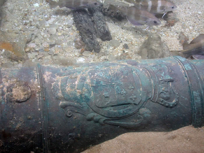 |
| The royal crest of King George I (1714-1727) discovered on a cannon helped confirm the identity of the site as HMS Victory sunk in 1744. |
The wreck of the Victory was discovered by Odyssey Marine Exploration in April 2008 while conducting an extensive offshore archaeological survey in the Western English Channel (over 4,725 square nautical miles) using side-scan sonar and magnetometry. Initial non-disturbance surveys indicated to Odyssey that the wreck's size along with its cannon form and dates corresponded with the long-lost wreck of the First Rate Royal Navy warship HMS Victory, which sank in 1744. The United Kingdom Ministry of Defence (MOD) was immediately notified of
the find.
The shipwreck is located outside UK territorial waters over 100km from the Casquets, where the ship was traditionally believed to have been lost. Conscious of the conviction that the Victory sank off the Channel Isles, the MOD granted permission for Odyssey to verify the identity by continuing to survey the site and recovering two bronze cannon.
A comprehensive non-disturbance survey and site investigation were conducted between May and October 2008. These activities included a side-scan sonar survey, measurement and photography of surface features, the production of a site photomosaic consisting of 2,821 high-resolution still images, and the recovery of a 12-pounder and 42-pounder cannon. An archaeological report detailing the findings of these surveys is available here.
The wreck site is vast. An artificial ellipsoidal mound rises 50cm above the sea floor. The central wreck mound covers an area of 60m north/south and 42m east/west. Cultural debris extends across a total area 84m north/south (anchor A2 to the rudder) and 305m east/west (between dragged cannon). Environmental evidence suggests that until recently a large sandwave present around 22m to the east originally covered and protected the wreck of the Victory.
Between 2008 and 2012, 50 bronze guns were recorded across the wreck's surface. A 5.60m-long v-shaped iron anchor is located at the northernmost edge of the wreck. The highly abraded 9.4m-long rudder at the south of the wreck marking the position of the stern is the largest structural remains found. Its concreted iron rudder head, main piece and sacrificial planking survive. Lead sheet-lined recesses known as scores between the rudder and sternpost prevented the rotating main piece from wearing out the wood's edges.
A pile of around 40 rectangular iron ingots used as ballast defines the westernmost edge of the site on a northeast/southwest axis. They correspond to the probable buried keel line. Iron ballast stiffened warship hulls and increased maneuverability. The Victory's ballast was cast by Miles Troughton at Sowley in the New Forest, part of the Beaulieu estate owned by the Duke of Montagu. The absence of wreckage west of the ballast suggests the warship struck the seabed to starboard. Down the centuries all of the ship seems to have collapsed east of this point.
A dense deposit of red brick in Area C1 to the north of the wreck reveals the position of the cooking galley hearth. First Rate warships needed 2,500 bricks to insulate decking from the oven's fire. Wooden plank sections, bronze and wooden rigging, cannonballs and glass bottle fragments are lightly scattered across the site.